For my first Litchi mission I wanted to find a big open area where drone recovery was possible if anything did go wrong. There are waterfalls in the canyons to the North which opened my eyes with a new level of understanding. If I had been aware of them I would have flipped my flight plan around and made sure I had enough altitude to get a clear shot of the canyon in the background.
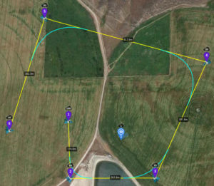
The mission went flawlessly. The POI was a spot in the field near where I was standing. Starting altitude is 350 ft AGL. In the first leg of 577 ft the aircraft descends to 280 ft.
It rounds a 90 degree turn for a 860 ft leg continuing to descend down to 62 ft AGL.
Rounding a slightly less than 90 degree turn the next leg is 1285 ft and the craft ascends to 98 ft AGL.
Rounding a 90 degree corner the next leg is 1700 ft flying level at 98 ft.
The final leg is 1190 ft also flying level at 98 ft.
The purpose was to see how changes in altitude and distance ‘looked’ on video. The point-of-interest was just a random point in the field I was flying next to, and the cell phone tower offers an object for seeing perspective.
Lessons learned from this mission
What I didn’t expect was how amazing the distant waterfalls in the canyon looked. I couldn’t see them from where I was standing. I had been thinking I needed to be close and was not willing to fly in the canyons until I had done a test flight where I could recover my bird if anything happened.
Reviewing the video on my big monitor I was able to get a feel for how changes in altitude and position on the horizon play into framing as I had hoped.
The more important lesson was altitude changes the equation to include more than you can see. Being aware of what is around allows you to consider including it in the panoramic vistas, like waterfalls gushing out of the canyon walls in the background. The paradigm is that you cannot see it from where you are standing and will take a while to master.
I could have easily taken some nice pictures and video from where I was. I was too involved in the flying my learning missions and once I was done I didn’t take time to just fly for fun and look around.
Summary
In the future even when the plan is to fly an automated mission I will start with a manual flight to get a view of the area and adjust the camera and other settings according to the conditions.
A pre-mission flight is a good idea to identify the highest obstacles height and validate that slopes in the terrain and obstacles are properly accounted for. It is important to check and set exposure, white balance, focus, and select filters for the flight based on actual conditions.
Experience is what it takes to develop an ‘eye’ and start thinking in terms of what the drone can see. I believe finding a good place to launch from that you can keep the drone in sight during the mission does not require you see what you are filming, only that you see the drone and it is well positioned.
Whenever possible I will take a manual flight and fly the ‘highlights’ of the plan to assure everything makes sense and ‘see’ if there is anything unexpected.
Footnote:
Originally I was hesitant to fly the Litchi mission because I had downgraded my firmware from .500 to .400 due to a known issue. The night before my flight I received a notification from Litchi that the issue had been addressed and so I updated to version 600. The test flight went well so I feel more confident in flying ‘real’ Litchi missions.